|
COMETS EARTH JUPITER KUIPER BELT MARS MERCURY METEORITES NEPTUNE OORT CLOUD PLUTO SATURN SOLAR SYSTEM SPACE SUN URANUS VENUS ORDER PRINTS
PHOTO CATEGORIES SCIENCEVIEWS AMERICAN INDIAN AMPHIBIANS BIRDS BUGS FINE ART FOSSILS THE ISLANDS HISTORICAL PHOTOS MAMMALS OTHER PARKS PLANTS RELIGIOUS REPTILES SCIENCEVIEWS PRINTS
|
Related Document
Download Options
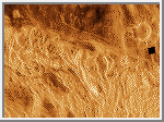
This image shows Alpha Regio. The bright lineated terrain is a series of troughs, ridges, and faults that are oriented in many directions. The lengths of these features generally range from 10 kilometers (6.3 miles) to 50 kilometers (31.3 miles). The topographic elevation within Alpha Regio varies over a range of 4 kilometers (2.5 miles). Local topographic lows, whose outlines are generally controlled by structures within the central region, are relatively radar-dark and filled with volcanic lavas. Source vents for this volcanism appear as bright spots within the smooth plains units. This image is in the public domain and is copyright free. |
