|
COMETS EARTH JUPITER KUIPER BELT MARS MERCURY METEORITES NEPTUNE OORT CLOUD PLUTO SATURN SOLAR SYSTEM SPACE SUN URANUS VENUS ORDER PRINTS
PHOTO CATEGORIES SCIENCEVIEWS AMERICAN INDIAN AMPHIBIANS BIRDS BUGS FINE ART FOSSILS THE ISLANDS HISTORICAL PHOTOS MAMMALS OTHER PARKS PLANTS RELIGIOUS REPTILES SCIENCEVIEWS PRINTS
|
Related Documents
Download Options
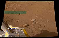
The hole in the ground produced by the first Robotic Arm dig at the landing site of NASA's Phoenix Mars Mission appears to the right of the three largest rocks near the center of this image. The hole is the width of the scoop on the end of the arm, about 9 centimeters (3.5 inches). It resulted from a practice dig during the mission's seventh Martian day, or sol 7 (June 1, 2008). The lander's Surface Stereo Imager took this image later that sol. The image is in approximately true color, produced by combining exposures taken through different filters. The green band at upper left is a portion where imaging data was incomplete in for one of the filters. The Phoenix Mission is led by the University of Arizona, Tucson, on behalf of NASA. Project management of the mission is by NASA's Jet Propulsion Laboratory, Pasadena, Calif. Spacecraft development is by Lockheed Martin Space Systems, Denver. |
